Yalta - Sevastopol private guide Sergey Tsarapora can suggest you to discover medieval pages of Crimean history and culture. One of them is a story about Eski-Kermen cave town.
The history of the appearance, life and fall of cave towns has been poorly researched, since there are no written sources and only archaeological excavations can help illustrate those bygone times Eski-Kermen has been more lucky in this respect Ten years of archaeological excavations, from 1928 to 1937, have thrown much light on its history.
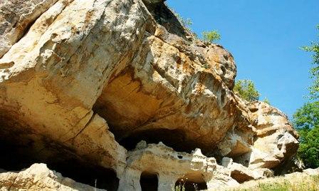
The mesa with the plateau-like top upon which Eski-Kermen stands stretches from south to north The length of the plateau is 1040 metres, it is 170 metres at its widest point and the height above sea level is about 400 metres. On all sides the mountain has sheer precipices whose height sometimes reaches 30-40 metres. It towers, like an island amid narrow and very picturesque valleys.
The structures at Eski-Kermen date from two periods the 6th—8th centuries, when the town's defence works functioned, and the 9th—13th centuries, when Eski-Kermen was a large, almost unprotected settlement after the Khazar invasion.
The Eski-Kermen fortress had four entrances. The mam entrance was in the southern part through the town's main gates, reached atone a meandering road hewn into rock. Three foot paths led to the town from the past and north.
A neculiar feature of the bigger cave towns is heir rather large area (10-15 hectares) and distinctive planning: town buildings were given only 2/3 of the area near the main gate. Another part, devoid of structures, was separated by a wall. During invasions of nomadic tribes such towns sheltered not only their dwe'lers but also residents of adjoining settlements. In peace time the inner space could serve as a market square, pasture or a camp for caravans.
Eski-Kermen was a first-rate fortress for its time. It met all the requirements of military construction. Eski-Kermen combined the exceptional relief of the surroundings with fortifications built by human hands. Sheer precipices of rock precluded the use of battering rams by attackers It was impossible to assault using mobile towers because of the abrupt rocky mountains. The commanding height of the fortress allowed all approaches to it to be covered with an ordinary bow. Besides, the defenders had at their disposal rather imposing weapons such as stone-throwers, which were installed at the juts of cliffs. Projectiles in the form of round stone balls have been found
during archaeological excavations.
The fortress defenders' main weapon, however, was the bow and arrow, slingshots and large round stones for throwing onto the enemy. The fortification walls, towers and cave casemates, peculiar only to Eski-Kermen, were fundamental for the defence of the fortress. It could stand a prolonged siege, as the very important problem of water supply was successfully solved on its territory, thanks to the construction of a well and cisterns for water storage Besides. Eski-Kermen residents could store thousands of metric centners of grain. Many sections of the defensive works contain grain pits hollowed out in the rock, which have survived to our day.
Eski-Kermen was not only a fortress, but also a major centre of trade and commerce. Agriculture, however, was the basis of its economy. Fertile valleys were used to cultivate vines, vegetables and fruit. This is evidenced wine-presses found by archaeologists, as well as traces of terraces for vineyards and vines in the environs of Eski-Kermen.
Its powerful defensive system, well-developed economy for the time and advantageous position made Eski-Kermen an important political and administrative centre in south-western Crimea. It retained its significance until the late 8th century, when an event happened that drastically changed the fate of the town.
This was an insurrection of the local population in the mountains of the Crimea against the domination of the Khazars. Headed by Bishop Ioann Gotsky, it took place in 787 and covered a large territory. Khazars suppressed the uprising and subdued the entire southwest of the Crimea. Having no need for fortresses, they ruined the defence structures of Eski-Kermen. But the town continued to exist for another 500 years as an open settlement. The defensive caves were adapted for various needs: for pantries, stalls for cattle, for churches, chapels, and burial vaults.
Eski-Kermen was finally laid waste in 1299 by the hordes of Emir Nogai. Its population was almost entirely annihilated. The town never returned to life. Time turned it into heaps of stones covered with earth and overgrown with grass and bushes. Its very name was forgotten. When Martin Broniewski visited it, he found only ruins which were "so old that neither the Turks, nor the Tatars, nor even the Greeks themselves knew their name." The name Eski-Kermen suits this town splendidly, for it means 'an old fortress' in Turkic.
The former grandeur of the town is seen in the ruins of the basilica, the well, remnants of dwellings and numerous cave structures of which about 400 have survived.
Of special interest is the Church of Three Horsemen. It is hewn into a large fragment of rock at the foot of Eski-Kermen. The church has two entrances. Between the entrances are high benches running along the walls. The church was lit with the help of two small windows.
To the right of the south-eastern entrance is a small chapel with a niche above a little grave, possibly that of a child. The second grave is at the northern wall. These graves were evidently the object of worship. This is confirmed by certain details in the arrangement of the church: a recess for candleholders, a niche with a cross above the child's grave. In the northern wall, near the larger grave, there is a single fresco, which gave the church its name. It portrays three riders in billowing cloaks, spears in hand. The names of those portrayed are not written. The middle horseman, striking a dragon with a spear, is St. George; the riders at his sides are holding their spears with tips upward. A boy sits on the crupper of the right rider's horse, and is holding onto the pommel.
The general tone of the fresco is a subdued blue. The halos of the horsemen are bright, golden-ochreous. A green field spreads beneath the horses' legs. Under the fresco runs a Greek inscription in black: "Painted are the holy martyrs of Christ for the salvation of the soul and absolution."
Researchers consider the fresco to be the monument of a battle, possibly so serious, that some of its participants were equated with St. George, the patron of all defenders of the homeland. The riders to the left and right of him could be the images of local heroes, considered saints and buried here. The heroic soldiers possibly became famous in the battle and then were canonized, and to commemorate them the Church of Three Horsemen was built. It is dated from the 12th—early 13th century, when the Crimea was threatened with Tatar invasion and. in this connection, the religious
popularization of the idea of the homeland defence gained strength The fresco was executed at that time.
To the south-west of the Church of Three Horsemen, in the southern outskirts of Eski-Kermen, stood the main gates of the town. But to approach them it was necessary to over-come the intricate system of their defence.


Along the mountain slope a road led to the main gales. It was used by the residents of the town for several centuries. Its ancienfness is testified by the deep ruts worn into the solid rock by the transport of that time the middle rut was stamped by horses hooves, the two lateral ones worn by wheels. The gates were the most vulnerable spot in a fortress, so ancient builders always paid great attention to them. A mighty well-thought-out defensive system was created not only in the immediate vicinity of the gates but at the approaches to them as well, to make them difficult for the
enemy to overcome.
The road makes several turns before it approaches the gates. At first it comes up to the foot of the western cave casemate. An avalanche of stones was thrown from embrasures of this casemate onto the heads of the enemy.
From that casemate the road turns sharply and comes to a cutting in the rock, then after two more sharp turns, it iioroaches the edge of the precipice, rises up to a small landing and only then turns to the gates.
The main gates were located at the start of a corridor – like passage hewn into the rock. Traces of the gates arrangements have survived to this day. Double-winged and opening inwards, they were locked with the help of wooden bars whose ends were slotted into the passage walls. The lower bar was fixed into the eastern wall (a square seat) while the upper one fitted into the western wall. The bars were used during a siege.
The passage into the town behind the gates is hewn into rock and makes the beginning of the main street. In the western wall of the passage two caves are found. The southern one could be premises for a gate-keeper, while from the northern cave you could ascend to the gate-tower.
It is difficult to form an opinion about the gateway structures because almost nothing has remained of them, but judging by cuts in the rock, the so-called beds, and stones which survived to the moment of the excavations an idea about the entire construction can be formed.
P. Sumarokov, a traveller and lover of antiquities, visited Eski-Kermen in the early 19th century and wrote "At the entrance to it the opening cut in the mountain makes a gate over which a vault of stone is seen..." There is no vault now, but it could be presumed that it was associated with the gateway tower. To the east and west of the tower ran the main fortification walls, whose thickness was about two metres. Battle areas with parapets, which once defended the approaches to the gates, were inserted before the walls, on top of rocky protrusions on both sides of the entrance to the city.
The final chapter of this article
Yalta -Sevastopol private guide Sergey Tsarapora